

PAGE LINKS
Overview
Jump To Page >
Dundee Ocean and Lake Frontiers Initiative and Neutrals (DOLFIN)
Overview
Climate change and related international agreements have important implications for extractives-led development.
DOLFIN is a research and know-how platform designed to support and strengthen the activities of the two existing natural resources centres (CEPMLP and the UNESCO Centre for Water Law, Policy and Science) and other departments of the University of Dundee, and to draw upon their expertise as well as external sources in a multi-disciplinary fashion by focusing on a field of study lying at the intersection of geoscience, international law and international relations, namely, the Law of the Sea, especially maritime boundary delimitation.
Example (YouTube) Videos
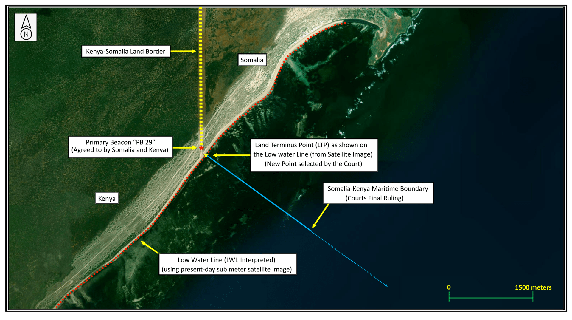
Kenya v Somalia (click on image below)
Côte d’Ivoire v Ghana (click on image below)
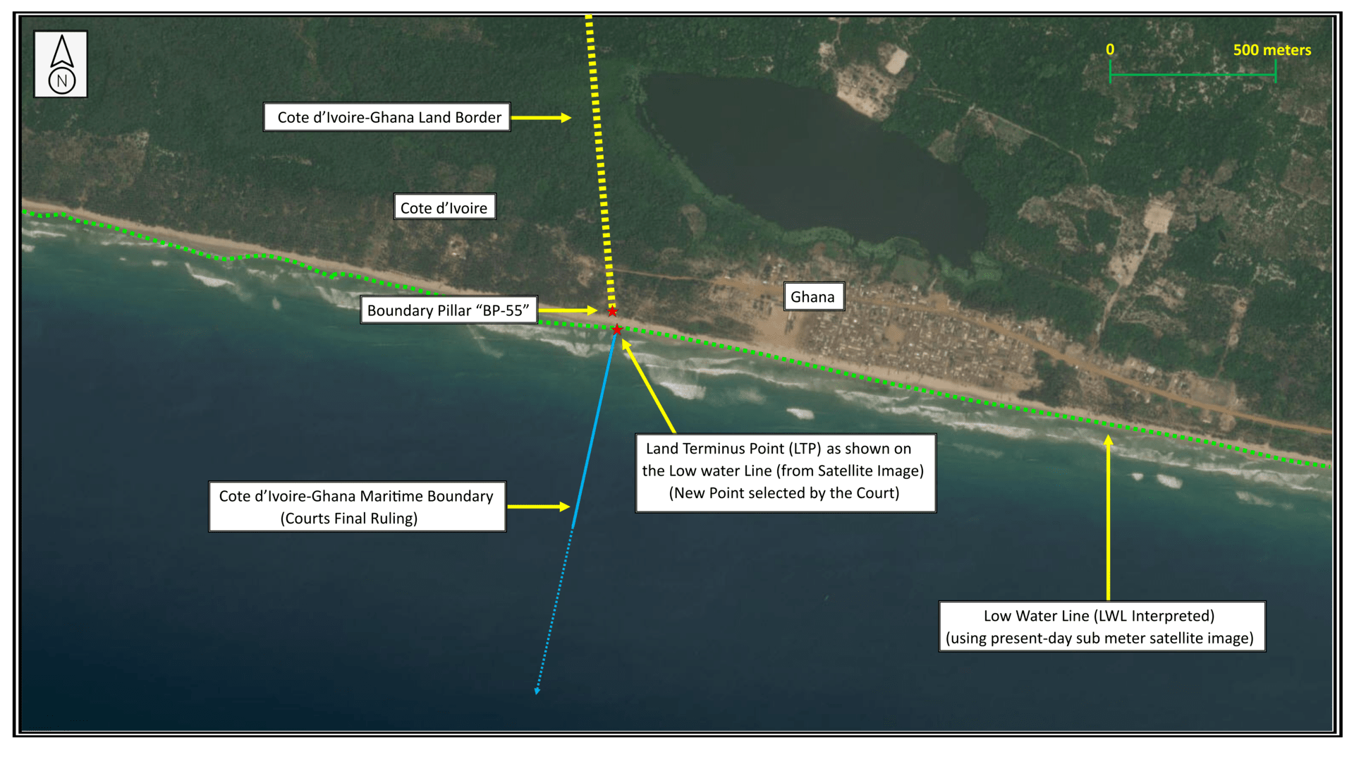
Data Source (for both images above): QGIS PI V13.14.16 (Sept.20,2020) OpenSource Software GIS Export / Satellite Image sub-meter © 2021 MAXAR Technologies.
Background
Fewer than half of the 500 or so potential maritime boundaries in the world have been agreed. The complex process of agreeing and fixing boundaries or making provisional arrangements can be time-consuming and expensive but once agreed can significantly contribute to the economic wealth of the affected countries. Disputes over maritime boundaries, some involving lakes as opposed to seas, regularly flare up around the world and sometimes result in armed skirmishes. Lake Countries (at present nine major lakes in Africa have oil and gas blocks issued and/or being issued) and Coastal States with competing claims to maritime areas routinely grant oil and gas concessions in disputed waters without the investors being fully aware of the underlying inter-State dispute. Indeed, maritime boundary disputes form a misunderstood and frequently overlooked area of investment risk management in the energy sector.
The creation of maritime boundaries involves the use of geology, oceanography, technology, money, law, history, politics and diplomacy. The modern Law of the Sea (LOS), as codified in the 1982 United Nations Convention on the Law of the Sea (UNCLOS), and the determination of maritime boundaries and related matters of interest to more than 160 Coastal States and the energy, mining, fishing and telecommunications industries involve a mixture of law, science and diplomacy. This calls for a multi-disciplinary approach.
UNCLOS, which has been ratified by 166 States and the European Union, is not just a set of principles but establishes legally binding obligations for each Party. States that have ratified UNCLOS are entitled to claim all natural resource rights to the water and ocean floor up to 200 nautical miles from their coastline and in exceptional cases even beyond that distance. Technological advances in deep water drilling and melting ice caps are associated with claims for an extended continental shelf (ECS) by the Coastal States involved. As of January 2022, 107 individual ECS claims had been formally deposited under UNCLOS by 83 countries worldwide (88 Full Submissions and 19 Preliminary Submissions), with submissions by additional countries possibly still to come. The present ECS maritime space, i.e., 200 nautical miles to “computed” geological ECS as claimed in these 107 submissions, covers approximately 37 million square kilometres globally.
In certain geographical settings, the rights set forth in UNCLOS can result in overlapping claims and boundary disputes which the disputing States are under a legal obligation to resolve in accordance with international law. Approximately four-fifths of the world’s known oil and gas reserves lies in contested regions. Of the 504 potential maritime boundaries in the world (inside the Exclusive Economic Zones (EEZ)), only some 256 are signed or in force — with 248 classified as “un-resolved and/or in-dispute,” meaning nearly 50 percent of all maritime boundaries remain “un-resolved.” The percentage of unresolved maritime boundaries is particularly high in Africa and Asia. In Africa alone, seven land-locked countries (Burundi, Ethiopia, Malawi, Rwanda, Uganda, Zambia, Zimbabwe) face un-delimited lake boundaries.
Mission Statement
- Through research, teaching, training and consultancy, DOLFIN promotes understanding of the legal and techno-scientific aspects of international maritime boundary determination, fosters the peaceful resolution of lake and ocean boundary disputes and addresses broader legal and geo-scientific questions concerning the developing technology in deep-water drilling, the changing nature of coastlines, rising sea levels, melting ice caps, and the geopolitical aspects associated with overlapping claims to lake and offshore maritime areas.
- Through the publication of topical maritime boundary studies within defined research projects and contributions to international conferences, DOLFIN contributes to the wider dissemination of knowledge and developments concerning international maritime boundaries in lake and offshore areas.
Goals
- Through the integration of international law, geoscience and diplomacy in a multi-disciplinary academic setting, to become a preeminent research, teaching and training platform for international maritime boundary delimitation and dispute resolution, thus creating impact and positively transforming the lives of those affected.
- To offer impartial advice to interested National and International Energy Companies, Ministries of Foreign Affairs, Energy and Finance regarding processes and tools to enable boundary solutions to be reached. Through deployment of a “Neutrals” team, DOLFIN offers disputing Lake Countries and Coastal States as well as energy investors affected by maritime boundary disputes know-how tools for resolving
their disputes and for assessing investment risk through the application of cutting-edge scholarship and expertise reflecting the latest maritime boundary technology and legal principles (the Neutrals team works with, and operates based on the consent of, the disputing parties with a view to developing boundary solutions reflecting the latest technology and legal principles). - The Neutrals are also available to serve as mediators or conciliators in respect of boundary disputes.
- To promote the goals and principles of the Charter of the United Nations and the UN Convention on the Law of the Sea.
DOLFIN is supported by a special module entitled “Ocean and Lake Boundary Disputes: (E)merging Law and Science” featuring simulation exercises and applying law-of-the-sea software based on real-world situations, to be offered by DOLFIN’s Directors.
Patron
 Prof. David J. Attard, D.Phil (Oxford), Vice-President of the International Tribunal for the Law of the Sea (ITLOS) in Hamburg and Director, IMO International Maritime Law Institute (IMLI), Malta.
Prof. Attard was Chairman of Exploration Committee in the Office of the Prime Minister of Malta in 1988, Advisor to the Secretary-general International Maritime Organization 1988-89, Special Legal Advisor to the Executive Director of the United Nations Environmental Programme in Nairobi 1989-91 and member of the Steering Committee for Human Rights (CDDH), Council of Europe, Strasbourg.
Founding Director
 Prof. Dr. Pieter Bekker, LL.M. (Harvard) (CEPMLP Chair in International Law; Partner, CMS) (covering all LOS Legal Aspects)
Pieter Bekker (The Netherlands) is an internationally recognized expert in the Law of the Sea, especially maritime boundary delimitation issues and disputes, having served as a staff lawyer for the International Court of Justice (ICJ), the world’s preeminent body for adjudicating maritime boundary disputes, and having consulted on maritime boundary issues for the public and private sectors, including Coastal States and national and international energy companies. A member of the New York Bar and the Association of International Petroleum Negotiators (AIPN), Prof. Bekker has appeared before the International Tribunal for the Law of the Sea (ITLOS), the UNCLOS adjudicatory body, as well as the ICJ and arbitral tribunals. He is the author of a number of law of the sea related publications and has lectured extensively on maritime boundary delimitation and dispute resolution both at the University of Dundee and internationally.
Contact: p.bekker@dundee.ac.uk (email)
Geology Director

Robert van de Poll, B.Sc., M.Sc.Eng.
Global Director Law of the Sea Fugro
Global Geo-Data Analysis & Geoconsultancy
CEPMLP Honorary Lecturer (covering all Global Law of the Sea Scientific Aspects)
Positioned as Director at Fugro’s Global Headquarters Robert manages all Global Law of the Sea (LOS) activities, responsible for 162 Countries Worldwide. Robert (Canadian) is an internationally renowned geologist and engineer (geodesist). He has completed 2000+ LOS related projects in 146/162 Countries. These LOS projects involve specialized consultancy, customized Desktop (DTS) studies, running regional seminars, workshops and hands-on training sessions for both Governments and Industry. These Clients include; Ministers’ Level (advising Governments) and/or Industry Senior Executives (for a variety of Corporate Applications such as (i) National / International Oil Corps. (ii) Renewable Energy Companies (iii) Telecom Industry (iv) Infrastructure (Pipelines / Ports-Harbours / Powerplants / LNG Terminals / Nuclear Power). LOS mapping projects impacts all Offshore Marine Applications. Robert designed, created and developed the CARIS LOTS (Law of the Sea) software (now Teledyne-CARIS) for the United Nations and maintains a truly unique state-of-the-art database, the most complete global assemblage of relevant digital Law of the Sea data of its kind concerning A to Z Law of the Sea (all numbers reflected on this Web page are derived from the Fugro database (December 2021)).
The 95+ Terabyte Global Fugro LOS database (complete comprehensive compilation for 162 Countries) archive of LOS-relevant datasets (both Legal & Scientific complete coverage of the World) was created/managed/used (by Robert) on 2000+ Law of the Sea projects Globally (in 146 of 162 Countries).
Robert is Honorary Lecturer at CEPMLP and also is the Geological Director, DOLFIN (Dundee Ocean and Lake Frontiers Initiative and Neutrals), at Dundee University, Dundee Scotland, UK. He is Honorary Fellow at (ANCORS), at the University of Wollongong, Australia, and also is a Visiting Fellow, at the IMO International Maritime Law Institute (IMLI), University of Malta, (Malta). This IMO organization is an agency of the United Nations. He annually delivers (teaches) Global LOS applications as an intensive 2-day Course (so far to 100-plus Countries ~ 2014-2021).
Contact: rvandepoll@fugro.com (email) & via LinkedIn (profile page).